
Annapurna Sanctuary and the Annapurna Circuit: Route, Altitude and Cost
The classic Himalayan walk, the acclimatisation schedule that makes it survivable, and a mountain that no one is allowed to climb.

Day by day: Nayapul to Annapurna Base Camp
The Annapurna Sanctuary trek and the full Annapurna Circuit are two different journeys. The Sanctuary route is an out-and-back walk from Nayapul to Annapurna Base Camp, at about 28.5300° N, 83.8793° E. The Circuit goes right around the Annapurna massif, through Manang, over Thorong La and down to Jomsom. This guide covers the Sanctuary in detail, with Circuit planning at the end.
Treat Nayapul as the start of the walking. A practical eight-day schedule covers about 60 to 70 kilometres on foot. Distances differ a little between maps and lodge-based itineraries, since some routes bypass upper Chhomrong and recent trail work has moved the measured endpoints. The sleeping altitudes below matter more than a precise kilometre count.
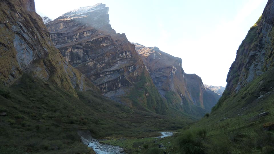
Day 1, Nayapul to Ghandruk: walk 9 to 11 kilometres, usually 5 to 6 hours with stops. Nayapul sits at around 1,070 metres, Ghandruk at about 1,940 metres. The route passes the edge of Siwai and then climbs through steep, wooded steps. Start by 7 am if you want to get to Ghandruk before the afternoon cloud, and to avoid walking beside the road traffic. Sleep altitude: 1,940 metres.
Day 2, Ghandruk to Chhomrong: walk 6 to 8 kilometres, normally 5 to 6 hours. The trail drops down to Chhomrong Khola and then climbs steeply into Chhomrong, where most lodges are at around 2,170 metres. It is a tiring day for just 230 metres or so of sleeping-altitude gain. That inefficiency is deliberate. Sleep altitude: 2,170 metres.
Day 3, Chhomrong to Himalaya: walk 9 to 11 kilometres, around 6 to 7 hours. The path goes through Sinprang, then climbs via Bamboo and Dovan to Himalaya. The village is named after the Himalayan range, not any single peak. Sleep altitude: 2,920 metres. If you woke with a genuine headache after the previous night, do not keep climbing just to stay on schedule.
Day 4, Himalaya to Machhapuchhre Base Camp, then down to Deurali: walk 8 to 10 kilometres, about 5 to 6 hours. The sunrise viewpoint at Machhapuchhre Base Camp is roughly 3,700 metres. Go on to Deurali, at about 3,200 metres, and sleep there rather than at the viewpoint lodge. The route can be wet and slippery, and cloud often hides the mountain by late afternoon. Sleep altitude: 3,200 metres.
Day 5, Deurali to Annapurna Base Camp: walk 3 to 4 kilometres, usually 2 to 3 hours. The trail climbs through a wooded gorge and comes out onto the moraine below Annapurna South. Annapurna Base Camp is at about 4,130 metres, and most people get there around midday. Stay at least one night if your symptoms and the weather are good. Sleep altitude: 4,130 metres.
Day 6, Annapurna Base Camp to Jhinu Danda: walk 8 to 10 kilometres, roughly 4 to 5 hours. The descent runs down through bamboo and rhododendron forest to Jhinu Danda at around 1,780 metres. This is the biggest single drop of the trek, and a sensible safety move after sleeping at the highest lodge. Jhinu has several lodges and natural hot springs below the village. Sleep altitude: 1,780 metres.
Day 7, Jhinu to Siwai: walk 8 to 10 kilometres, about 4 to 5 hours, and carry on to Birethanti if you want a full day on foot. Siwai sits at roughly 1,250 metres; Birethanti is near 900 metres. The lower trail is hot in the daytime and can mean long stretches of rough road walking. Sleep altitude: 1,250 metres if you stop at Siwai.
Day 8, Siwai to Nayapul: walk 2 to 5 kilometres, approximately 1.5 to 2.5 hours, depending on where you slept and the Birethanti road junction. A jeep from Nayapul to Pokhara takes about three hours. You may be tempted to combine Days 7 and 8 into one 15 to 17 kilometre day, but that turns the descent into a long, hot slog. A single weather buffer day makes the trip nine trekking days instead of seven.
Why the schedule looks inefficient, and why Deurali is the key
Day 4 is the most confusing part of this trek. You climb to 3,700 metres, look at Machhapuchhre, then walk back down to 3,200 metres. Anyone who paid for a summit view might see that as wasted effort. In fact it is the heart of the acclimatisation plan. The body adapts to altitude partly through time spent high, but it recovers better when it sleeps lower.
Watch the sleeping altitudes, not the highest point you reach. You sleep at 2,170 metres in Chhomrong, 2,920 in Himalaya, 3,200 in Deurali and 4,130 at Annapurna Base Camp. The night at Deurali comes after a higher visit to Machhapuchhre Base Camp, without adding another night of poor sleep at 3,700 metres. The next morning's climb to 4,130 metres is a big jump, but it is manageable if you have no symptoms.
Going straight from Chhomrong to Annapurna Base Camp would lift your sleeping altitude by nearly 2,000 metres in two nights. The gradual version gives your body several chances to recover while still exposing it to thin air. Sleeping low also means you can drop down quickly after a bad night. That matters, because roughly one in three trekkers develop altitude sickness on this route.
A faint headache after a steep climb is not the same as a persistent one that comes back after rest or water. A real headache, especially with nausea, dizziness, unusual exhaustion, poor balance or broken sleep, means you should not sleep any higher. Go down at the first real headache, not after another night at the same altitude to see if it improves.
“The descent to Deurali is the acclimatisation, not wasted walking.” Sita Gurung, lodge keeper in Chhomrong
If altitude illness gets worse, the safest response is to walk down at least 500 to 1,000 metres, then eat, rest and reassess. Confusion, being unable to walk unaided, breathlessness at rest or repeated vomiting all call for emergency evacuation. Oxygen can help while you arrange a descent, but it is no substitute for going lower. Sleeping pills and alcohol can hide symptoms and make the next morning more dangerous.
If the headache is getting worse, go down. Missing Annapurna Base Camp is a manageable disappointment. Acute mountain sickness is not.
Machhapuchhre: the fish tail that remains unclimbed
Machhapuchhre has two summits, about 6,996 metres and 6,663 metres, joined by a narrow ridge. Seen from Deurali, Annapurna Base Camp or the trail below Machhapuchhre Base Camp, the upper summit and sloping ridge can look like a fish's tail. The name is usually translated as “Fish Tail” or “Mountain of the Fish Tail”.
For Gurung communities around the Annapurna region, Machhapuchhre is sacred and tied to the protection of the Annapurna valley. Local custom forbids climbing it. Nepal’s authorities do not issue ordinary climbing permits, and there is no established public route to the summit. The prohibition is cultural, not simply a shortage of climbers.
Do not treat Machhapuchhre as a side project for experienced mountaineers. Local opposition is direct, and an unauthorised attempt can create trouble for residents as well as climbers. Annapurna Base Camp is the walking destination. On this trek the mountain matters for the way it stands above the sanctuary, not as an invitation to try for the top.
The best views usually come early in the morning or late in the afternoon. During the monsoon, cloud can cover both summits by late morning. From the ridge above Deurali the mountain can look much closer than the 3,700-metre viewpoint lodge suggests, but the stretch between Deurali and the viewpoint crosses exposed ground. Do not walk it in thunder, heavy rain or poor visibility.
Annapurna Sanctuary and ACAP rules
The upper basin is usually called the Annapurna Sanctuary, but the wider protected area is the Annapurna Conservation Area Project, or ACAP. ACAP was set up in 1987 and covers about 7,553 square kilometres, which makes it Nepal’s largest conservation area. It takes in forests, high ridges, river valleys and settlements in Kaski, Manang and Mustang districts.
ACAP's rules are written for a landscape that is already under pressure. Trekkers should stay on marked trails and must not cut new routes. Hunting, trapping, tree cutting and plant collection are banned. Do not dump rubbish, wash with soap in streams, discharge waste water or light fires outside designated areas. In practice that means carrying rubbish down, using a filter bottle instead of dumping waste in the forest, and keeping food scraps off the trail.
Drone flights need permission under conservation-area rules. Bringing a drone does not make flying it allowed. Check with ACAP and the relevant local authority before you bring one into the area. Commercial photography, guiding and other tourism businesses may also need local registration, which is why a registered trekking agency is simpler than arranging services yourself in the villages.
The rules are strict because ACAP protects the watershed that feeds the Pokhara valley, wildlife such as blue sheep and snow leopard, and the forest cover on steep slopes prone to erosion. The narrow paths also take a beating from heavy foot traffic and monsoon rain. ACAP is not run like a national park with a large ranger force. Local communities and their tourism committees do much of the enforcement, so how the rules are applied can vary.
Two practical habits matter more than anything else. Do not cut across grass or forest because it looks shorter, and do not assume the conservation rules stop applying just because there is no ranger at a lodge. Thousands of individually reasonable shortcuts add up to a damaged trail.
Tea houses, food, freezing nights and the shower nobody mentions
Accommodation on the Sanctuary route is mostly simple tea-house lodges. The stated room rate commonly includes breakfast and dinner, sometimes lunch as well. Rates vary with the season, the room size and how many people share. Recent typical prices for a shared room with meals are about NPR 1,500 to 3,000 in Ghandruk and Chhomrong, NPR 2,500 to 4,500 in Himalaya and Deurali, and NPR 3,500 to 6,500 at Machhapuchhre Base Camp and Annapurna Base Camp. Expect the upper end in the busy weeks of October. Check whether the quoted rate is per room or per bed, and ask about a single supplement if you are travelling alone.
The food is simple and repetitive, because that is what supplies allow. Dal bhat, vegetable curry, soup, potatoes, eggs, momos and noodles turn up on most menus. A main meal costs roughly NPR 400 to 800, momos about NPR 250 to 500, noodles NPR 400 to 700 and a hot drink NPR 200 to 500. Prices are lower in the lower villages and higher above Deurali. Dishes given an international name often cost more and may not be worth ordering. If meals are included in your room, check exactly what is covered before paying extra for a second dinner.
Supplies get thinner above 3,500 metres. Kitchens buy fewer ingredients, menus shrink after 5 pm and some lodges stop taking orders once the dining room closes. Arrive before 4.30 pm, eat whatever is hot and bring snacks up from a lower village. Meat is rare at the highest lodges, since refrigeration is limited. Drink water that is treated, boiled or filtered, and do not fill your bottles from streams, even clear ones.
The cold is worse than the daytime temperature suggests. At Annapurna Base Camp, daytime temperatures in good October weather may reach 8 to 15°C, while a clear night can drop to around minus 5°C. Wind makes the walk back from dinner feel colder still. Many lodge rooms have blankets but no central heating, and some have very thin walls. Bring a sleeping bag with a comfort rating around minus 10°C, a liner, warm layers for sleep and a headlamp. Do not rely on a thin summer sleeping bag, because some lodges charge extra for blankets.
The shower is the detail most route summaries leave out. At the upper lodges, a shower usually means a bucket of water behind a curtain, not a cubicle with a mixer. Hot water may not be available at all, or only during limited hours. A shower with water costs roughly NPR 300 to 800 at ABC and Machhapuchhre Base Camp. At Jhinu, the natural hot springs are a separate attraction, with a small entrance fee, basic changing cubicles and a crowd at busy times. If you want a private hot shower, ask for one and pay for it; do not assume the room rate includes it.
Most toilets are squat-style, and some charge NPR 100 to 300 to use. Toilet paper and hand soap are not always provided. Power is usually available for several hours in the evening rather than all night, and charging a device costs around NPR 300 to 700. Carry a power bank and a small headlamp. Expect dogs, generators, prayer flags, other trekkers and thin walls to disturb your sleep as much as the temperature does.
Permits, licensed guides and what a porter costs
Foreign trekkers need two permits for the standard Sanctuary route. The Annapurna Conservation Area permit costs NPR 3,000. The Nepal Tourism Board TIMS card costs NPR 2,000. Together the official fee is NPR 5,000 per person. An authorised trekking agency can get both in Pokhara, or you can ask the Nepal Tourism Board about getting a TIMS card directly. Carry your passport, since the permit and TIMS details may be checked at the entry point or at checkpoints. Permit fees can change, so confirm the amount just before you leave rather than trusting an old blog post.
A licensed Nepali guide is compulsory for foreign trekkers on this designated route. The rule is there because the trail crosses remote settlements and high ground, where altitude illness and weather emergencies call for local knowledge. Use an agency registered with the Nepal Tourism Board, check the guide’s identity card, and make sure the contract covers the trek dates, route, food, transport, insurance and cancellation terms. Going it alone and simply skipping the guide can get you refused at a checkpoint.
A licensed porter’s base wage is usually around NPR 5,000 to 7,000 per trekking day, with food, lodge accommodation, transport and insurance either included in the agency package or added as expenses. For a nine-day job, a realistic all-inclusive budget is NPR 60,000 to 85,000 before any tip. A guide is often quoted at roughly NPR 8,000 to 12,000 per day, with expenses and transport listed separately. Ask for an itemised price, because “guide and porter” packages vary a great deal.
A porter normally carries a main pack of about 20 kilograms, within the agency’s limit. Carry your own day bag, water and warm clothing. A tip of 10 to 15 percent is customary when service has been reliable, roughly NPR 5,000 to 10,000 for a nine-day porter and a little more for a guide who dealt with a difficult evacuation or weather delay. Do not hand a porter 25 kilograms; the quoted rate assumes a safe load.
October and November first, then March and April
The best season is October and November, then March and April. Late October and November usually bring the clearest weather and the most reliable trail, though lodges are busy and the nights turn cold. March and April are warmer, with more water use and the odd spell of spring rain. The lower forest can still be damp in early March. May and June get progressively warmer, dustier and less settled before the monsoon arrives.
From late June through August, heavy monsoon rain can wash out sections below Chhomrong, damage the road between Pokhara and Nayapul and close trails after landslides. Streams rise fast, and helicopters cannot always fly in poor visibility. Leeches are common below about 2,500 metres. The upper sanctuary can look dramatic in a break in the rain, but the lower approach may still be blocked for days. This is not the season for a fixed departure date or a nonrefundable international flight.
Do not book your flight home too early. Leave at least two full buffer days after the trek, and ideally add a night in Kathmandu before an international departure. A domestic Pokhara-to-Kathmandu flight on the same day the trek ends leaves you exposed to road delays, missed connections and weather. In monsoon, flights can be cancelled for several days, and even a helicopter evacuation may not be able to leave straight away. Build spare time into the ticket instead of trusting a tight connection.
Time, transport, costs and what to avoid
Allow seven to nine trekking days plus two nights in Pokhara. Eight days gives a sensible balance between acclimatisation and a tiring descent. Nine is better if you split the Jhinu walk, take a rest morning or want a weather day in hand. The full Annapurna Circuit is a different undertaking: roughly 160 to 220 kilometres and usually 12 to 18 walking days through Jagat, Namche, Manang, Thorong La at 5,416 metres, Muktinath and Jomsom. It normally does not include Annapurna Base Camp. Adding the Sanctuary spur to the Circuit takes roughly six to eight more days and should not be squeezed into a short itinerary.
The road from Pokhara to Nayapul takes about three hours over roughly 70 to 90 kilometres, depending on where you are picked up and on roadworks. A shared jeep normally costs around NPR 1,500 to 3,000 each way, while a private vehicle is roughly NPR 10,000 to 15,000 per trip. Tourist buses usually go only as far as Birethanti, from which Nayapul is another 45 to 60 minutes by jeep or about an hour on foot. Start early, because the road can slow down after rain.


Annapurna Sanctuary and the Annapurna Circuit, Nepal
For the two nights in Pokhara, Lakeside has the biggest concentration of restaurants, ATMs and travel offices, but it can be noisy and prices around the lake are higher. The old bazaar area is quieter and usually cheaper for meals. On the trek, the tea-house lodges listed along the route are the practical choice. Book the upper lodges directly for October, confirm that meals are included, and ask about hot water and charging if either matters to you.
For a nine-day Sanctuary trek, budget approximately NPR 170,000 to 280,000 per person if a guide and porter are shared between two travellers. That rough total covers NPR 5,000 for permits, about NPR 25,000 to 45,000 for your own lodge rooms and the meals included with them, your share of guide and porter costs, shared jeep transport, drinks, charging and tips. It leaves out international flights, gear rental and insurance. A solo traveller paying for a dedicated guide and porter can spend roughly NPR 260,000 to 400,000. The full Circuit costs more, because it lasts longer and crosses additional permit zones.
Buy travel medical insurance with a trekking altitude limit above 5,500 metres and helicopter evacuation cover of at least US$5,000. A rescue can cost several thousand US dollars, and an ordinary travel policy may exclude altitude illness or trekking above a stated height. Read the altitude and evacuation clauses instead of relying on the phrase “adventure travel”. Keep the policy number and local emergency contacts with your guide and travelling companions.
Avoid compressed itineraries that sleep above 3,000 metres too quickly, guides working without a registered agency, lodge bookings with no meals included, and itineraries that book a same-day international flight after the trek. Do not count on a hot shower, a fixed menu or a flight schedule during the monsoon. Carry a water filter, treatment tablets, a warm sleeping bag and enough cash for lodge extras and tips. Above all, do not keep going up with a worsening headache. Walking down is the right response, even if it means missing the view from Annapurna Base Camp.
From readers
Traveller experiences
Personal notes and ratings from readers who have been to Annapurna Base Camp.
Checking your session…
No experiences yet.
Sign in to be the first reader to describe this place.
Keep reading
More stories from this collection are coming.
Plan this journey
Journeys connected to this story, quietly linked and never intrusive.