
Everest Base Camp and the Khumbu Valley: A Practical Trek Guide
The highest national park on earth, a moving glacier and an honest account of Everest Base Camp: a seasonal tent settlement with no summit view, plus a practical Khumbu route.

What Everest Base Camp actually is
Sagarmatha National Park takes in 1,148 square kilometres of Koshi Province. People often call it the highest national park on earth, and that is because Mount Everest sits inside its boundaries. Everest Base Camp, at roughly 28.0026, 86.8528, marks the end of the standard southern trekking route. Walking from Lukla to base camp and back is about 60 to 70 kilometres each way. Add the Gokyo extension and the short walks around Namche, and a full circuit usually comes to 120 to 150 kilometres.
South Everest Base Camp sits at 5,364 metres, on the lateral moraine of the Khumbu Glacier. A moraine is the rubble left along a glacier's edge, which means the ground here is rock, gravel, ice blocks and glacial dust all mixed together. It is not a village, a resort or a viewpoint with a row of cafes looking at Everest. Mostly you will find expedition tents, storage shelters, a few service structures and a patch of ground used for helicopter landings.
Base camp turns into a rough tent city between April and May, the spring climbing season. Expedition teams pitch yellow, orange, blue, red and green shelters for sleeping, cooking and sorting gear. Paths get worn between the tents, generators run wherever they can, and porters haul loads through the camp. The settlement shrinks in October and November, though it stays busy with trekkers and support staff. Outside those weeks you may find little more than a few tents and the mountain.
You will not see the summit from base camp at all. The Nuptse and Lhotse walls and the Khumbu Icefall block it. From camp you get the glacier, the icefall and the lower faces of the surrounding mountains, but not Everest's top. The famous sunrise view comes from Kala Patthar or, depending on the weather, Gokyo Ri. North Base Camp is over the border in Tibet and needs separate Chinese permission and travel arrangements.
“Base camp is a working gravel yard under a moving glacier. The summit is above the icefall, not in front of you.” Samar Sherpa, trekking guide, Namche
The Khumbu Icefall and why Everest is hard
The Khumbu Icefall is not a frozen waterfall. It is the steep stretch where the Khumbu Glacier drops away from the Everest and Lhotse mass, falling from roughly 6,000 metres to about 5,200 metres. Some parts of the ice shift 3 to 5 metres a day. The glacier splits into towers known as seracs, opens crevasses and sheds blocks that pile up below as a broken field of ice.
Climbers heading out of base camp cross the lower Khumbu Glacier before entering the icefall on the way to Camp I at about 6,065 metres. Beyond that the route runs over the Lhotse Face, across the South East Ridge, through the Bottleneck and up onto the summit ridge. Serac collapse, hidden crevasses, rockfall and avalanche all form part of the climb. The icefall is the first serious technical section, but only one part of an ascent that also calls for glacier travel, fixed-line work, severe cold and long spells at altitude.
The shifting ice also explains the near-constant helicopter traffic and the heaps of expedition gear at base camp. A closed route can reopen within hours, and it can also shut without warning. Up in the upper Khumbu, a weather forecast is never a guarantee. For trekkers the icefall is mostly a view and a reminder of how big the mountain is. Climbers need another set of skills, insurance and judgement altogether.
Namche Bazaar is a trading town, not a theme park
Namche Bazaar lies at about 3,440 metres and is the biggest settlement in the upper Khumbu. It grew up as a trading town on the old route between Tibet and Nepal. Tibetans brought salt, wool and other goods, while Sherpa and Nepali traders dealt in grain, livestock, potatoes and manufactured goods. Tourism now provides most of the income, yet the town still serves as a supply centre for the villages above it.
In practical terms, Namche has teahouses, restaurants, bakeries, pharmacies, gear shops, equipment rental, banks, an ATM, a post office and a helicopter pad. The ATM works often enough to be useful and fails often enough that you should turn up with cash. Most trekkers buy or confirm a Sagarmatha permit here, change money into Nepalese rupees, pick up batteries and stock a few days of snacks before heading higher.
Most visitors treat Namche as an Instagram stop, walk to a viewpoint and carry on up the next morning. The town is better used as an acclimatisation day. Spend at least one night, walk to Khumjung or Thamserk at a pace that lets you talk, eat, sleep and otherwise do nothing strenuous. If a headache starts here, this is the place to stay put and reassess rather than push on.
Teahouses and food above the trail
Teahouses are the standard accommodation all through the Khumbu. Most are family-run lodges with wooden or metal rooms, thin walls, shared bathrooms and blankets instead of central heating. A basic room in Namche commonly costs NPR 2,500 to 5,000 a night. Above 4,000 metres, expect roughly NPR 1,000 to 2,500. Some villages charge less because demand is lower, though that says nothing about the heating or the cleanliness.
Above 4,000 metres the food is often better than visitors expect. A hot bowl of thukpa or a plate of dal bhat costs around NPR 600 to 1,200, fried noodles or rice NPR 500 to 1,000, and garlic soup usually NPR 300 to 600. These are plain meals, but they arrive hot, fill you up and tend to serve you better than a big dinner after a day on the trail. Menus get shorter the higher you go, and meat is expensive and not always on offer.
Tea runs about NPR 200 to 400. A hot shower, if the lodge has one, usually costs NPR 300 to 800. Charging a device and Wi-Fi are often billed separately at NPR 200 to 500. Bottled water can cost NPR 300 to 600, so ask whether treated or boiled refill water is available. Rooms generally have electricity but no dependable heating, and the mobile signal can vanish for hours. Carry a headlamp, a charged power bank and enough cash for the villages higher up.
Porters, loads and daily rates
Porters carry group tents, kitchen equipment, food, fuel and expedition gear, and they may take a trekker's duffel as long as the load stays within the permitted limit. Regulations cap the load at 20 kilograms. A porter should have proper boots, a rain jacket, warm layers and insurance. When a porter is handed a 30-kilogram load, old footwear and no insurance, the agency is pocketing the savings at the expense of the person doing the work.
The Nepal Trekking Agents Association, or NTAA, has long been the main industry reference for trekking wages, though local porter associations may quote different rates. Its last widely published minimum put a licensed guide at US$30 a day and a porter at US$25 a day. For a 2025 trip, many operators were budgeting US$35 to US$40 for a guide and US$30 to US$35 for a porter. Ask the agency for the current rate card in writing, and pin down whether rest days and weather delays are paid. These figures are wages, not tips.
A tip of roughly 10 to 15 percent of the agreed wage is normal for good service, but it should not be used to make up for a poor base rate. Book through a registered agency rather than hiring someone informally at the airport. Ask to see the porter's insurance and equipment, and do not assume that everyone carrying luggage is a licensed porter. Walking at the group's pace is part of the job too, so a group that regularly leaves its workers behind is treating them badly.
The 13-to-15-day walking altitude schedule
A workable 13-day walking plan from Lukla goes like this. Day 1: fly to Lukla and walk to Phakding at 2,610 metres, usually 3 to 4 hours. Day 2: trek to Namche at 3,440 metres, 5 to 6 hours. Day 3: rest in Namche. Day 4: walk to Deboche at 3,820 metres, 6 to 7 hours. Day 5: continue to Dingboche at 4,810 metres, 3 to 4 hours. Day 6 crosses to Everest Base Camp at 5,364 metres and then drops to Gorak Shep at 5,170 metres, 4 to 5 hours including time at the camp.
Day 7 is Kala Patthar followed by a descent to Lobuche at 4,950 metres. Day 8 is for rest and an acclimatisation walk near Lobuche. Day 9 takes the pass above Dzongla to Gokyo at about 3,850 metres, normally 6 to 7 hours. Day 10 covers Gokyo Ri and the lakes, 4 to 6 hours. Day 11 goes to Thame at 3,800 metres or Chhukung at 3,700 metres, Day 12 to Namche, and Day 13 to Lukla, 6 to 7 hours if the weather behaves. Keep Days 14 and 15 free for a missed flight, a trail closure or a medical delay.
How high you sleep matters more than the highest point you reach during the day. Above 3,000 metres, most people do well if their sleeping altitude goes up by no more than about 500 metres a day, with a rest day every three or four days. Above 4,000 metres, many trekkers find 300 to 500 metres easier to handle. A route can include 1,000 metres of climbing and descending while the gain overnight stays small. Do not add a pass just because the map makes it look easy, and do not go higher if you have symptoms.
Gokyo, the lakes and the quieter alternative
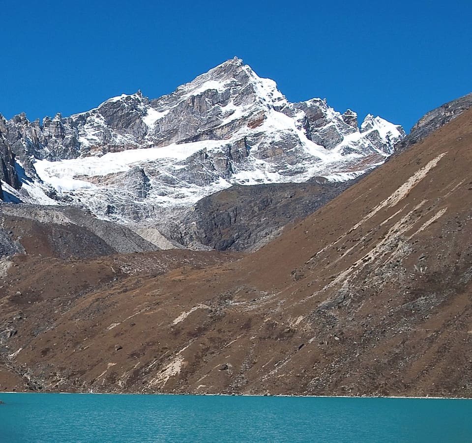
The Gokyo route leaves the base camp circuit at Lobuche, crosses a high pass near Dzongla and then drops down to Gokyo. That walk is roughly 12 to 15 kilometres and takes 6 to 7 hours. Gokyo sits at about 3,850 metres, with lodges beside the largest lake and a cluster of higher lakes within a day's walk, among them Dud Pokhari, Thagnak Pokhari and Cho Pokhari. Lake levels change, and the main Gokyo Lake can dry out during parts of winter and spring.
Gokyo Ri reaches about 5,333 metres on most maps. From the top you get a wide view over Everest, Nuptse, Cho Oyu, Machapuchhre, Kangtega and Lhotse. It is not always clearer than Kala Patthar, but the mix of peaks, lakes and fewer people on the trail is often better. On a clear October or November morning, Gokyo and Gokyo Ri regularly draw fewer than half as many visitors as Kala Patthar and the base camp trail. There is no fixed daily figure, and spring-season crowds can be similar.
The lodges in Gokyo are basic, with shared toilets, solar power that comes and goes and short menus. Book ahead in spring, but check that your lodge will still be open in late October or November. The Gokyo route makes its own altitude demands, so it is not automatically safer just because it finishes lower than base camp. It is a good alternative when you want mountain views without every morning turning into a crowded walk.
Kala Patthar at sunrise
Kala Patthar tops out at 5,545 metres and stands roughly 1.5 to 2 kilometres above Gorak Shep along the walking path, with about 370 metres of ascent. The usual round trip takes 4 to 5 hours. For sunrise in late October and November, leave Gorak Shep at 4:30, reach the viewpoint around 6:00 and expect the sun at roughly 6:10 to 6:30 Nepal time. Groups can make the ridge look busier than it is, so starting earlier cuts the queue on the final stretch.
Nobody can give you an honest, fixed percentage for a clear sunrise. The Khumbu forecast covers an enormous area, and cloud can arrive or clear within 30 minutes. In late October and November a clear horizon is common enough to make the climb worthwhile, though it is never guaranteed. One useful test is the cloud level: if low cloud sits below about 4,500 to 5,000 metres, the peaks stay hidden however long you wait. Any operator promising a guaranteed summit view is selling a slogan rather than reliable weather advice.
The cold is what people underestimate. Air temperature can drop below minus 15 degrees Celsius, and wind can push the wind chill below minus 25 degrees even when the thermometer reads something milder. Wear insulated gloves, a hat, a balaclava, a down jacket and a windproof outer layer instead of relying on a fleece. Carry water and food, because the exposed ridge is cold even when the walk from Gorak Shep felt easy. If the wind is strong or visibility is poor, turn back. Getting down safely is worth more than a photograph taken through cloud.
Kala Patthar and monastery access rules
Foreign visitors need the Sagarmatha National Park entrance permit, which costs NPR 3,000. It covers the usual routes to Everest Base Camp, Gokyo, Kala Patthar and Tengboche Monastery. Normally there is no separate ticket for Kala Patthar. You can arrange the permit through an agency or get one at the park checkpoint, but carry the passport you used for it and be prepared for an inspection at checkpoints.
Monastery rules vary more. Tengboche, the largest monastery in the Khumbu at about 3,670 metres, usually asks for a donation or entry contribution of roughly NPR 100 to 500, and some monasteries add a camera charge of NPR 100 to 500. Carry NPR 500 to 1,000 in small notes rather than assuming there is a card machine. Opening hours generally run from morning to late afternoon, but ceremonies, repairs, funerals and local events can shut the main buildings with no advance notice.
Do not rely on an old blog or a map to tell you what is open. Paths can close after landslides, snow or trail work, and local authorities can bring in temporary restrictions that never make it online. Ask the Sagarmatha park office in Namche, the local municipality or the lodge where you slept the night before. Do not fly a drone in the park without prior permission, which is rarely given to visitors. At a monastery, ask before photographing monks or going into prayer rooms, and do not treat a working place of worship as a photo set.
Lukla, the flight in and the walk from Solukhumbu
Lukla airport sits at 2,860 metres with a single short runway of roughly 460 metres, hemmed in by steep hills. A scheduled flight from Kathmandu takes about 30 to 45 minutes in good conditions, though the whole airport process often eats three to six hours because aircraft are held back for weather. One-way fares commonly run NPR 18,000 to 35,000. Most airlines set a combined baggage limit around 15 kilograms, so check the carrier's current rules and make sure your duffel stays within the allowance.
Wind, cloud, poor visibility and aircraft congestion cancel Lukla flights on a regular basis. A cancelled flight is normally rebooked for the next morning, not later the same day. Do not link a Lukla flight to an international departure on the same afternoon. A charter helicopter makes the trip in about 25 to 35 minutes and costs roughly NPR 120,000 to 190,000, but cloud affects it too, so treat it as an option for a genuine emergency rather than a missed connection.
The walking alternative begins in Solukhumbu at about 2,336 metres. A route through Kharikhola and villages such as Tamrang, Chumling or Sujikhar reaches Lukla in roughly 50 to 65 kilometres and three or four walking days, depending on which village route you take. It is not a day hike from the road head. If the Lukla flight is cancelled, this can soak up one or two days without costing you the whole trek. From Kathmandu itself the walk takes about 9 to 12 days, so think about a bus to Bandipur or another lower trailhead and allow more buffer.
How long to allow
Allow 13 walking days for the standard Lukla, base camp, Gokyo and return route, then add two reserve days to the plan. One reserve day makes sense for a cancelled Lukla flight; the second covers trail delays, a lodge closure or a slower descent. Book the first and last nights in Kathmandu separately from the trek. If you are flying into Lukla, arrive at least a day before your first scheduled trek day, and never treat the last day as the same day as an international flight.
Total walking time usually lands between 70 and 100 hours, depending on the group, side walks, weather and how many rest days you take. The route is not technically hard, but altitude, load and uneven stone steps make a fast pace a waste of effort. At 4,000 metres and above, five hours of walking can feel like a full day. Pick a schedule that can absorb a delayed start rather than one that only works in perfect weather.
When to go
Late October to late November is the best season. The air is often clearer than in the spring rush, the jet stream causes less disruption, and the lower winter snow has not peaked yet. Cold is still a factor, especially before sunrise, and some lodges start closing in the second half of November. Book Gokyo and any lodge near the end of the route, then confirm it is still operating shortly before you arrive.
Late March to mid-April is the other practical window. It is warmer but busier, with more tents at base camp and less room in the lodges. December through February can give excellent clear-air views, though the trail may be under snow, some lodges close and the winds can be severe. The June to September monsoon is a bad time to trek: rain, swollen streams, landslides and disrupted flights. Late September and early October can work, but conditions turn less predictable as the season changes.
What the trek costs
The Sagarmatha permit costs NPR 3,000. A basic room for 12 to 14 nights usually comes to NPR 25,000 to 45,000, and food, water, tea, showers, charging and Wi-Fi add another NPR 25,000 to 40,000. An independent trek with a porter but no guide works out at roughly NPR 85,000 to 125,000 before flights, insurance and equipment. Add a licensed guide and the total usually lands at about NPR 130,000 to 185,000.
Agency packages for 13 to 15 days commonly start around US$700 to US$1,000 with a local operator, rising to about US$1,000 to US$1,600 with a stronger guide and better support. Premium operators can charge more than US$2,000. The package should set out the guide and porter daily rates, how many rest days are included, meals, permit, emergency support and exactly what happens if a flight is cancelled. A cheap quote that leaves out meals, porter wages or an acclimatisation day may only look cheaper because those costs turn up later.
Flights between Kathmandu and Lukla usually add NPR 36,000 to 70,000 return. Travel insurance commonly costs US$40 to 100 and should cover medical treatment and helicopter evacuation to at least 5,500 metres. A rescue policy with a low evacuation cap will not do for the Khumbu. Tips come on top, and insurance claims often need the guide or agency to coordinate the rescue and guarantee payment.
How to reach Lukla and what to do when the flight fails
The usual arrival is a morning flight from Kathmandu, then lunch in Lukla and a short walk to Phakding. If the flight is cancelled, ask the airline for the next available departure and use the wait to eat, rest and check that your permit and cash are in order. Do not spend the delay walking to Namche. The first flight often lands close to midday, and rushing uphill after a broken night is poor acclimatisation practice.
If the delay runs past a day, take the Solukhumbu walking route or move to a lower trailhead by bus. Save a helicopter for medical need rather than using it to protect a tight international connection. Keep your trekking kit ready to move without two days of repacking. During a delay in Lukla, a spare fleece, dry socks, water and snacks are more useful than a day of sightseeing.
Where to stay and where to eat
Stick to teahouses along the whole route unless you have real backpacking experience and want to carry a tent and a full kitchen. Established places in Namche include Hotel Tibet, Hotel Everest View and several smaller family lodges. Tengboche Lodge is the standard stop below the monastery. In Gokyo there is Gokyo Lodge, Dragonfly Lodge and others around the lake. In Lukla, Hotel Everest View, Hotel Himalayan Slate and Khumbu Yhool have been around a long time. Ownership, prices and opening dates change, so confirm before you rely on a particular property.
Above 4,000 metres, eat where there is a kitchen instead of carrying lunch every day. Dingboche and Pheriche usually have better ingredients and prices than the temporary food stalls at base camp. A hot dal bhat, thukpa or garlic soup costs about NPR 600 to 1,200. If the lodge is remote, order dinner the night before, keep snacks from Namche and do not count on a restaurant being open when you arrive late.
Accommodation at base camp is usually expedition camping, not a normal teahouse room. Unless an expedition package includes it, sleep at Gorak Shep, Pheriche or Lobuche after visiting base camp. You will save money, eat better and still get to the glacier. The only reason to stay at the camp is if the expedition team has arranged it specifically.
What to carry and what to leave behind
Bring a layered system: a quick-drying base layer, a light fleece, an insulated down jacket, a waterproof shell and trekking trousers. Add insulated gloves, a warm hat, sun gloves, sunglasses rated for strong alpine light and a brimmed sun hat. Late November may call for microspikes, particularly around Kala Patthar and on shaded sections after snow. A headlamp with spare batteries is essential, and a full-day water bottle should be paired with a bladder or a second bottle.
Pack a first-aid kit, blister treatment, personal medication, hand sanitiser and a basic sleep cover. Trekking poles help on stone steps and spare your knees. Teahouses provide blankets, so most walkers do not need a heavy sleeping bag, though a silk liner is useful. Do not bring an inflatable mattress on the standard teahouse route unless you have confirmed the lodge provides one. Leave room in your duffel for the porter's load, and check the airline baggage limit.
Water purification matters more than carrying every drink from Kathmandu. Many lodges have refill stations and treated water, but the supply and the treatment method are not always consistent. Use your own purifier, boil the water or buy sealed bottles if you are unsure. Do not treat an oxygen bottle as a substitute for descending. A canister can help during a rescue, but it does not make it safe to keep climbing when someone has altitude illness.
The warning worth reading: a headache can become a brain emergency
Cold is the problem most people prepare for, and usually it can be managed. The dangerous pattern is a headache that turns into a brain illness. Acute mountain sickness may start as a headache with nausea, dizziness, unusual fatigue or poor sleep. If the headache gets worse despite rest, fluids and an ordinary painkiller, stop going up. Confusion, odd behaviour, hallucinations or an inability to walk in a straight line can point to high-altitude cerebral edema. Someone who cannot walk heel to toe needs to descend immediately, not a stronger painkiller and a warmer sleeping bag.
Breathlessness while resting, a persistent cough, tightness in the chest, blue lips or frothy pink sputum can indicate high-altitude pulmonary edema. It may show up without a severe headache. The response is the same: descend immediately, give oxygen if you have it and evacuate by helicopter when necessary. A helicopter cannot fly through the same cloud that stopped it landing, so walking down must stay the first plan. Keep the sick person with a companion and never leave them alone in a lodge.
Never ascend with a headache that is getting worse. If someone is walking in a circle or cannot walk straight, get them down the mountain now.


Everest Base Camp and the Khumbu Valley, Nepal
In the Khumbu, descend at least 500 to 1,000 metres and reassess. Acetazolamide can lower the risk of acute mountain sickness when it is prescribed for the right person at the right dose, but it does not make an unsafe ascent safe. Carry a satellite communicator if the budget stretches to it, because mobile coverage is patchy. Go through the symptoms with the group before you reach Dingboche, since decisions get harder when several people are tired and unwell.
What to avoid on this trek
Do not add passes to fill spare days, skip the Namche rest day or rush once you are above 4,000 metres. Steer clear of schedules that demand more than about 500 metres of sleeping altitude gain on consecutive days. Skip alcohol and sleeping pills, which make dehydration worse and can mask symptoms that matter. Do not leave someone with symptoms in Namche, Dingboche or Pheriche because the weather looks bad; their descent will only get harder as they weaken.
Do not book an international flight for the same day as the planned return from Lukla. Never buy a permit from an unofficial broker without a receipt, and do not accept a porter who has no equipment or insurance. Do not count on a helicopter arriving. Do not photograph monastery ceremonies without permission, fly a drone or leave food out for ravens and marmots. Above all, treat a worsening headache or breathlessness as a reason to go down, even if it means missing Kala Patthar, Gokyo or the summit view you paid to see.
From readers
Traveller experiences
Personal notes and ratings from readers who have been to Everest Base Camp.
Checking your session…
No experiences yet.
Sign in to be the first reader to describe this place.
Keep reading
More stories from this collection are coming.