
Upper and Lower Mustang: Permit, Wind, Caves and the Road to Lo Manthang
A kingdom that stayed separate until 1959, a permit that takes a week, and a wind corridor that dictates the shape of every day.

Upper Mustang sits north of Kangro La; Lower Mustang takes in the southern approach through the Kali Gandaki valley. Most treks use both. They begin around Jomsom, cross the gorge country, call at Muktinath and end in the walled town of Lo Manthang. Count on 8 to 12 days for the standard circuit, and note that this does not cover the four-day side trip to Gyakar or Lar.
The Mustang Kingdom kept a separate legal status until Nepal became a republic in 1959. After that change, roads, Chinese-built tracks, the old trade routes and close ties with Tibet shaped the district. It is administered today as part of Gandaki Province, yet entry to Upper Mustang is still controlled. Movement above the gorge is a serious undertaking, not an unrestricted road trip.
The restricted permit and the checkpoints
The restricted-area permit for Upper Mustang costs US$500 per person for seven days. That is the Nepal Mountaineering Association permit itself, not US$500 on top of a separate NMA entrance fee. It is tied to a seven-day period and cannot be bought on its own at the trailhead. Pay another US$500 and you get seven more days, provided the Nepal Mountaineering Association approves an extension through your agency.
Book it through a registered Nepali trekking agency in Kathmandu or Pokhara. The agency files the permit application and arranges the licensed Upper Mustang guide you are required to have. Give yourself at least seven days before departure, and two weeks if you are travelling in March, April or October. Expect to supply passport details, nationality, a photograph and your dates. Most agencies also set a two-person minimum, so a solo traveller needs to be placed in a group before paying.
The checkpoints are real. Police posts at and around Jomsom, Salleri or Bhesisuwor, Lho, Takam, Muktinath and sometimes Gyakar may ask to see the permit. The order changes, but you should expect to stop at several. Carry the original passport you used for the application, not just a photo or an email from the agency. If the name, passport number or dates do not match, expect a delay while your guide contacts the agency.
If your route also enters designated parts of Lower Mustang, the agency may add the separate US$50 Lower Mustang permit. Whether you need it depends on the villages and roads involved, so check the itinerary before you leave rather than waiting for a checkpoint to explain the charge. The agency should issue all required permits before you leave Jomsom. Even a full Upper Mustang permit is not permission to enter Chinese territory.
The Kali Gandaki gorge and the wind coming through it
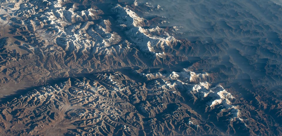
The Kali Gandaki runs between the Annapurna and Dhaulagiri massifs. In its deepest section the river sits roughly 5,500 metres below the surrounding rim, which is why people commonly call it the world's deepest canyon. The claim is about vertical relief, not the width of the valley. From Jomsom the river lies far below the town, and the walking route continues through Kagbeni, Chhuksang and Ekal in the lower gorge.
The wind is what catches most visitors out. Afternoon westerlies get funnelled through the gorge and up the Kali Gandaki valley towards Upper Mustang. In exposed places, sustained speeds of 30 to 50 kilometres per hour are common, with gusts above 60 kilometres per hour. Loose dust makes it feel stronger. The air can look clear in the morning and still be too rough for an easy ridge walk by noon.
Walk early, stop at eleven, and save exposed passes for the morning. Guides usually put the Kangro La and Thorong La crossings before breakfast, because that is when the wind is most dependable. Lunch tends to happen in the lee of a rock or a building rather than out on an exposed trail. By two in the afternoon the wind can shake a vehicle door hard enough to rattle the windows. Tsering Dorje, who runs a family guesthouse in Lo Manthang, says his staff leave at seven, eat early and wait for the gusts to ease.
The wind also makes a walk feel longer than the map suggests. A signpost you can read at 8 a.m. may be hard to hold onto at midday. Snowfields on the passes turn loose in the afternoon once they warm up. Headlamps, gloves and a windproof layer belong at the top of the day pack, not the bottom. The rule is simple: if the route leaves you exposed, start before the wind arrives.
Lo Manthang and the grid inside its wall
Lo Manthang stands at about 3,840 metres above sea level. It is a rectangular walled settlement roughly 1.5 kilometres long, laid out on a grid of narrow lanes with low, flat-roofed houses. Much of the outer wall goes back to the fifteenth century. The earthen buildings are usually whitewashed, and many still have mud brick under the plaster. From the ridge above town, the street pattern looks far more regular than it does at ground level.
The main palace stands near the centre of the grid, a big whitewashed building with four main storeys and several roof levels, often called the four-sided palace. Its roof terrace gives the best practical view of Lo Manthang, because you can take in the lanes, courtyards, flat roofs and perimeter wall all at once. The view does not stop at the town. On a clear morning you can see the brown plain around it and the peaks on the Tibetan border beyond the wall.
Go up to the roof early, before the narrow stairs and the entrance get busy. In peak season, tour groups fill the main square and the guesthouses. Outside the festival period it is calmer, though the altitude still makes an unhurried pace necessary. Most visitors stay in family guesthouses within walking distance of the palace. Rooms are simple, bathrooms are often shared and heating is limited, but being central saves you repeated climbs through the lanes.
Lo Manthang is a working town, not a preserved set. You will see children on their way to school, shopkeepers rolling up metal shutters, vehicles being repaired and livestock driven through the streets. April and May bring more walkers; October brings festival traffic. The best local food is plain and good: dal bhat, thukpa, noodles, potatoes, momos and Tibetan bread. Accommodation and meals are covered in more detail at the end of this article.
Choekhor Choekhor monastery and the cliff caves
Choekhor Choekhor Gompa stands in the upper part of Lo Manthang. The white, three-storey monastery holds a large prayer wheel and images associated with Chenrezig, the Buddhist figure of compassion. It is still an active religious building, not a museum. Shoes come off inside and voices stay low. Photographs of monks or ceremonies should only be taken after asking.
A short climb above the upper lanes brings you to a small complex of rock-cut cells in the cliff. Some of the chambers were hermit retreats; others were used for storage and monastery work. They are easy to miss, since there is no big visitor entrance. Ask a monk, a guide or a local about the current access rule rather than walking into an open doorway on your own. There is little inside, and several cells are still in religious use.
Allow 30 to 60 minutes for the climb, plus another hour if you stop at the cells. Start early, because the exposed path catches the same wind as the rest of the valley. A small donation is welcome, but there is no need to treat the place like a ticketed attraction. Do not confuse this upper cliff complex with Tangbe, the larger cave village two to three hours beyond Lo Manthang, or with the remote cave fields at Lar and Gyakar.
Lar and Gyakar, the remote Upper Mustang caves
You reach Lar from Muktinath, with two full walking days in each direction. The route climbs out of the Kali Gandaki basin and crosses dry, open country before arriving at a cliff with more than 100 cut cells. Some chambers are big enough to have been dwellings; others are barely shelters for a hermit, or rooms for seasonal storage. This is a serious side trip, not a stroll from Muktinath after breakfast.
Gyakar is two days each way from Lo Manthang, normally by way of Ghiling and the cliffs below Dhulkar. The caves sit in several separate groups rather than on one single face. Outside festival and school-holiday periods, both Lar and Gyakar are almost empty. On an ordinary weekday a group of three or four may have the site to itself, though another trekking party can turn up without notice.
There is a basic lodge at Gyakar, but beds are limited and you cannot rely on getting a room at short notice. Accommodation around Lar is even less predictable, so many teams bring tents and sort out food in advance. Mobile signal is weak, and shops are few and far between. Carry a full day's water, a headlamp, repair tape and a rubbish bag. Do not leave food paper or plastic in the cells, and do not enter chambers that are locked or newly plastered.
Each cave destination adds roughly four days to a standard Mustang circuit. Doing both Lar and Gyakar adds at least eight days, along with a fair amount of food and porter cost. An 8 to 12 day itinerary cannot take in both without cutting the main route into short, rushed sections. If the Upper Mustang backcountry is the point of your trip, pick one cave field.
Muktinath, Kangro La and the old Tibetan trade route
Muktinath lies in Lower Mustang at about 3,760 metres, close to the upper entrance of the gorge. The settlement is small, but pilgrims come from Nepal and India to the temple complex. Its most recognisable feature is a row of 108 water taps fed by a spring. The water is believed to purify, and pilgrims rinse or drink from it according to their custom. The local name refers to release from worldly attachment, though the original Sanskrit and Tibetan names are used differently in different accounts.
Kangro La, also known as Muktinath Pass, rises to roughly 3,760 metres and links the Muktinath side of the Kali Gandaki with the road basin around Lo Manthang. Snow can lie on the trail well into spring, and even an October crossing may mean ice. Cross in the morning. The pass is not the Tibet border, and getting over it does not put a traveller in China.
The old road north through Lho and Sharughku once connected Mustang with Tibet and is still a trade route for local communities. Salt, grain, wool, yak products and livestock have crossed the frontier here for generations, and yaks and sheep remain part of the local economy. The border area is controlled, though. Foreign visitors cannot get into the Tibet Autonomous Region of China just by carrying on along the road. You need a Chinese visa and specific border permission, and the route is normally closed to ordinary trekkers.
That distinction matters, because plenty of trekking descriptions make the old trade road sound like an open border crossing. It is not. Stay on the permitted side, follow your guide, and do not walk past a checkpoint to get a better photograph. Crossing an international border is a separate administrative process, not part of the standard Upper Mustang permit.
Losar, Narchyu and the October literature festival
Losar is Tibetan New Year and the busiest family celebration in Mustang. It usually falls in February or March, though the date shifts with the Tibetan calendar. Houses are cleaned, new robes are made, butter lamps are lit and big butter sculptures are prepared. Public events in Lo Manthang run for several days. The religious calendar governs everything here, so an English date printed months in advance can turn out wrong if the local celebration moves.
Narchyu, the big spring festival, usually follows in March or April and lasts about five days. It brings processions, large drums, masked cham dances and the arrival of sacred images at Lo Manthang. The central square is crowded from early morning until the performances end. This is a serious local event, not a show put on for visitors. A guide can explain the sequence, but shoving through barriers or treating the masked dancers as photo props is bad behaviour.
The Mustang Literature Festival takes place in October. It is a small, multi-day programme of readings, poetry, panel discussions and talks on local history, with sessions in Nepali, English and local languages. Some readings and film screenings bring people from Kathmandu, Pokhara and overseas. It is still a modest event, closer in feel to a series of talks than to a big book fair. Confirm dates and venues each year with the festival or your agency.
Travelling for a festival takes more planning. For Losar, Narchyu or the October event, book guesthouses and road seats three to six months ahead where you can. Roads and flights are busier, and Lo Manthang has only so many beds. If quiet walking and time in the caves matter more to you, go in September or late November instead. Even then, anyone arriving for a festival should keep one spare day, since a delayed jeep or a cancelled flight can throw off the whole programme.
The jeep road and the monsoon problem
Most people arrive on a flight to Jomsom and then take a shared jeep up the road. The drive to Lo Manthang is often described as four hours, but five or six is more realistic once you count permit stops, bad stretches of road and a meal break. A seat usually costs about US$15 to US$25, while a private jeep is roughly US$100 to US$150. Jeeps leave when they are full rather than to a timetable, so do not plan a connection out of Jomsom for the same afternoon as your flight.
Much of the road is broken tarmac, and you get dust, engine trouble and long waits behind freight vehicles. It makes the return to Jomsom much easier, but it does not do away with local walking. Muktinath, Choekhor Choekhor, Tangbe, Lar and Gyakar still take hours or days on foot. Anyone choosing the road for comfort should not expect to cover the standard circuit in three days.
Between June and August, heavy rain can make the lower Kali Gandaki gorge impassable. Landslides, washouts and swollen streams close sections of road around Beni, Bagarchhap and Jomsom, sometimes for days on end. Upper Mustang sits in a rain shadow and may stay dry while the access road is cut. That helps little if the jeep cannot get out of the gorge or the flight from Pokhara is cancelled.
Road conditions in the monsoon are uncertain, and official closure advice often arrives late. Never book a non-refundable international flight for the same day as a planned Jomsom connection. A sensible July or August itinerary needs at least two or three buffer days, and you should be ready to walk between Jomsom, Muktinath and Upper Mustang if vehicles cannot get through. May and November can bring storms too, so check conditions instead of assuming those months will be dry.
How long to allow for the circuit
Allow 10 to 12 days for the standard Upper and Lower Mustang circuit. That covers the short walk from Jomsom, the local visits around Lo Manthang and a buffer for road delays. A fit walker can do the main route in eight days, but there is little room for bad weather, a missed permit or a slow day. The advertised 8 to 12 days is a range, not a promise that every section takes the same number of hours.
A common sequence goes Jomsom to Chhuksang on day one, Chhuksang and Kagbeni to Muktinath on day two, and Muktinath to Lo Manthang on day three. Day four is spent in Lo Manthang, with another if you want Choekhor Choekhor. The route then continues to Ghiling, the Thorong La area and Muktinath before returning through Chhuksang or Jomsom. Walking days run from roughly four hours to eight, depending on where the pass falls and where you stop.
Add four days for Gyakar and another four for Lar. Doing both, or doing one at a slow pace, turns the trip into a 16 to 20 day trek. Do not squeeze a cave extension just to save a few days in Kathmandu. The walking gets longer, the wind gets harder to manage, and the schedule leaves no margin to recover if snow blocks a pass.
What the trip costs
The fixed major cost is the US$500 seven-day Upper Mustang permit. A licensed guide commonly costs US$25 to US$35 per trekking day. Rooms in family guesthouses in Lo Manthang usually run about US$10 to US$20 for a private room with a shared bathroom, and three meals add roughly US$20 to US$35 a day. A shared jeep seat from Jomsom generally falls between US$15 and US$25.
A porter costs roughly US$15 to US$20 a day, not counting meals, though rates vary with group size and load. On a longer trek, tips of US$40 to US$100 for a guide and porter are reasonable when the service has been good. Drinks, charging, showers, festival accommodation and personal spending are extra. The US$50 Lower Mustang permit may also be added if the route calls for it.
A realistic all-inclusive ground cost for 10 to 12 days is US$900 to US$1,400, leaving out international flights and personal shopping. Some agencies advertise lower totals, so ask exactly what is included. A quote that comes close to the permit price alone cannot also cover a guide, accommodation, meals and transport without pushing costs somewhere else. Ask for a written breakdown, and confirm whether the quoted seven-day permit covers the whole walking itinerary.
Carry cash in Nepalese rupees. Cards and ATMs outside Jomsom and Pokhara are unreliable, and an ATM may simply be empty. Small teahouses take cash for tea, meals, showers and phone charging. International flight prices vary too much to be worth quoting, but the Pokhara to Jomsom sector is short and often hit by weather. Buy travel insurance that covers trekking above 3,500 metres and helicopter evacuation, because the nearest full medical service is a long way off.
When to go
The best seasons are March to May and September to November. March, April and May give the clearest mountain views and the most reliable trail surfaces, though nights in Lo Manthang can drop below freezing. September and October are good for walking, with a greater chance of late-season rain than in March. November is usually clear but getting colder. The October literature festival and the spring festivals are the busiest reasons to travel then.
June to August is the least reliable time for access, because the lower gorge road is vulnerable to monsoon damage. The weather inside Upper Mustang can stay dry, but a closed road changes everything. December to February is not a normal trekking season. Thorong La can lie under deep snow, guesthouse services may shut, and nights in the upper villages can drop below minus 15 degrees Celsius. Only experienced winter parties should consider that period.
Altitude is a planning factor even in the good seasons. Lo Manthang sits at 3,840 metres and Muktinath at about 3,760 metres. Headaches, poor sleep and a reduced appetite are common in the first two days. Avoid alcohol and strenuous exercise when you arrive. If someone gets a severe headache, cannot walk straight, becomes confused or struggles to breathe at rest, the right response is to descend and get medical help, not to push on for the sake of the itinerary.
How to reach Jomsom and the Upper Mustang road
Most people fly from Kathmandu to Pokhara and then take a second flight to Jomsom. The Pokhara to Jomsom leg takes about 15 to 25 minutes, while the first sector usually lasts 25 to 40 minutes. From Jomsom, the road north to Lo Manthang takes about four hours by jeep. It makes sense to reach Jomsom a day before the trek starts and to keep at least one day between your last walking day and an onward flight.
You can travel overland from Pokhara through Beni and the Kali Gandaki gorge when the road is open. The bus or jeep to Jomsom takes roughly four to six hours, but landslides can stretch that considerably or stop it altogether. The old trail is another option, though it eats days you would rather spend in Mustang. If your trek is short, the road and the flight save enough time to be worth the cost and the risk of a delay.
Jomsom airport is small, and delays caused by wind are common. Do not schedule a Pokhara connection just minutes after your scheduled landing at Jomsom, and do not put an international flight on the same day as the jeep from Jomsom. In monsoon season, both the flights and the road can fail on the same day. A night in Jomsom is cheap next to missing an international departure.
Where to stay and what to eat
Lo Manthang has family guesthouses such as Hotel Royal Mustang and Hotel Grand Shambala, plus smaller houses around the walled lanes. They make the practical base for most Upper Mustang itineraries, since the town is within walking distance of the palace, Choekhor Choekhor and the start of the walk to Ghiling. Muktinath has only a few lodges, Jomsom has more hotels, and Chhuksang and Ekal mostly have simple lodges or tented camps.
A room in Lo Manthang normally comes with a bed, thin blankets and sometimes a heater for a few hours in the evening, but do not treat it as a heated hotel. Bathrooms are shared, hot water may cost extra and electricity can run only during set hours. During Losar, Narchyu and the literature festival, reserve well ahead. Outside those periods you can usually find a walk-in room in Jomsom, though not always in Lo Manthang.
The standard meal is dal bhat, usually with vegetables and sometimes meat. Thukpa, momos, noodles, fried potatoes and Tibetan bread are the usual alternatives. A guesthouse may include breakfast in the room rate, but dinner is often ordered in the evening for the next day. Tea costs roughly US$1 to US$2, and a bottle of drinking water generally costs US$1 to US$3. Do not drink untreated tap or spring water, even where it looks clear.
Toilets may be squat or Western, and paper is not always provided. Carry tissues, hand sanitiser and a small towel. Ncell coverage is patchy in Upper Mustang, while NTC is more dependable around the larger settlements but not always at the pass. Download offline maps before you leave Jomsom. Mobile data is no reliable way to reach an agency from a cave camp.
What to avoid and a warning worth reading


Upper and Lower Mustang, Nepal
Do not set off for Upper Mustang without the agency-issued permit and a licensed guide. Do not treat the Chinese border as a walkable extension, and do not cross an exposed pass in the afternoon. Avoid the monsoon road unless your itinerary has a genuine buffer. Do not assume a Jomsom flight will keep to its schedule, and do not leave the permit in a hotel safe while you take the original passport onto the trail.
The day is planned around the wind, not around you. Walk early, stop at eleven, and do not put an exposed pass or ridge crossing in the afternoon just because the morning was clear.
Also avoid bringing more luggage than you can manage yourself. A porter is useful for food, tents and group equipment, but everyone should still carry water, a wind layer, gloves, sun protection, a headlamp and basic first aid. At 3,800 metres the sun burns exposed skin quickly, while ground in the shade can freeze. Keep plastic, wrappers and sanitary waste with you until you reach a place that can deal with them. There is no easy rubbish collection along the cave routes.
A workable plan: submit the permit at least ten days ahead, allow 10 to 12 days in Mustang, reach Jomsom the night before the trek and keep one spare day before an onward flight. Stay in a family guesthouse in Lo Manthang, walk in the morning, and treat the jeep as transport rather than the trip itself. Roads and schedules help, but wind, checkpoints and the permit are what really decide how the journey goes.
From readers
Traveller experiences
Personal notes and ratings from readers who have been to Mustang.
Checking your session…
No experiences yet.
Sign in to be the first reader to describe this place.
Keep reading
More stories from this collection are coming.
Plan this journey
Journeys connected to this story, quietly linked and never intrusive.